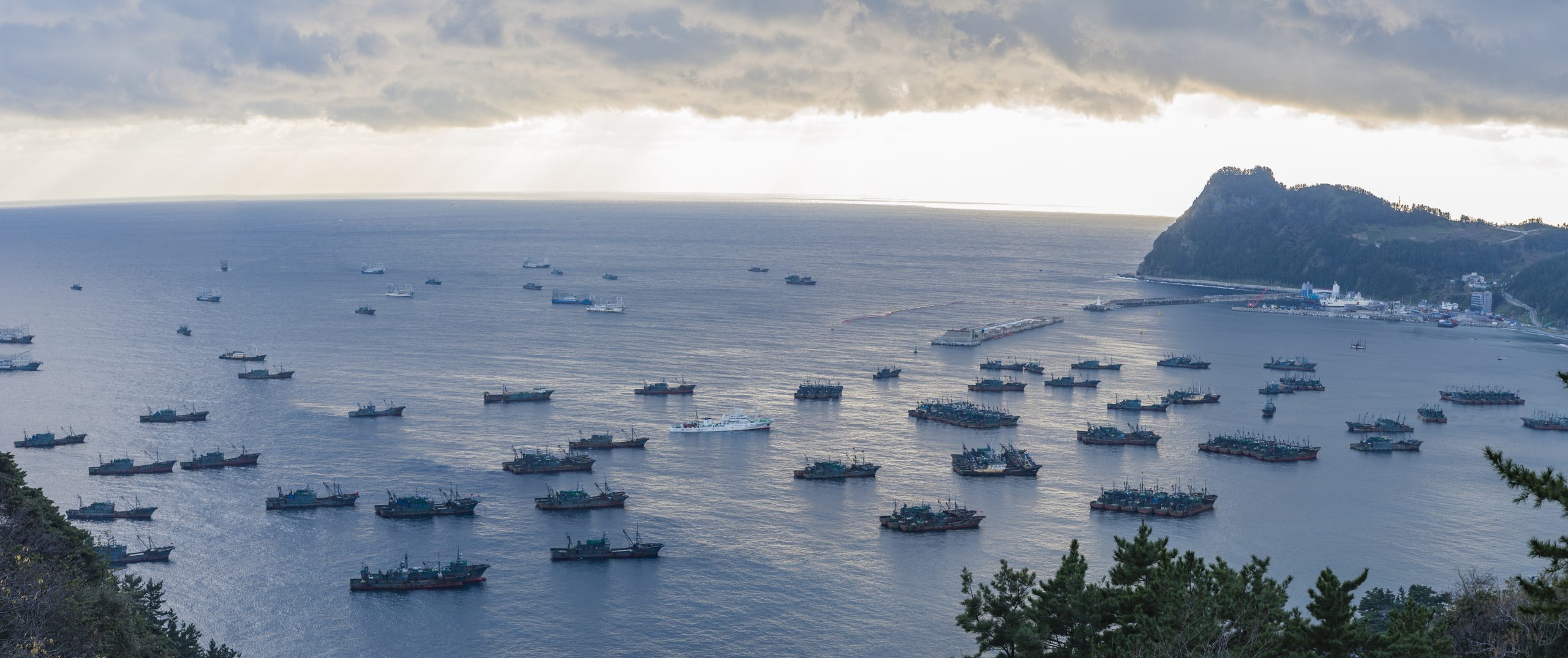
Chinese fleets anchored in Sadong port, Ulleung-do, South Korea, December 6, 2016. Trawlers (30-35m) and lighting boats (55-60m) are shown. © Ulleung-gun County Office
Illegal fishing is a pernicious threat to the health of fish stocks and marine ecosystems that undermines food security for legitimate fishers. To date, the practice has been notoriously difficult to monitor due to “dark fleets.” These vessels do not publicly broadcast their locations or appear in public monitoring systems. Synthesizing and applying existing technologies in new ways is emerging as a solution to shine a light on dark fleets and promote greater transparency on the ocean.
A recent study by Global Fishing Watch uncovered the largest ever-recorded case of illegal fishing by dark fleets. The researchers used an unprecedented synthesis of satellite data, radar, and artificial intelligence to reveal the dark fleets operating in the waters between the Koreas, Japan and Russia, which are among the world’s most disputed and poorly-monitored waters. The study found more than 900 vessels of Chinese origin which likely caught more than 160,000 metric tons of Pacific flying squid (worth nearly USD 500 million) over two years. Increased pressure on the fishery and illegal fishing pose a challenge for squid stock management, as reported catches have declined by 80 percent and 82 percent in South Korean and Japanese waters respectively since 2003.
In this interview, David Kroodsma, director of research and innovation at Global Fishing Watch, explains the significance of this study and why it may signal a new era in ocean transparency and accountability.
This project is an unprecedented example of combining advanced satellite technology and the analytical skills of the Global Fishing Watch team with on-the-ground knowledge and reporting from investigative journalist Ian Urbina. Can you provide our readers with some background on how this project developed and the level of collaboration and information sharing involved across multiple organizations and governments?
The project began when one of our data scientists, Jaeyoon Park, visited a researcher, Jungsam Lee, at the Korea Maritime Institute in South Korea. Jungsam wanted to know if it was possible to track some of the foreign vessels that he believed were violating UN sanctions by fishing illegally in North Korean waters. Jaeyoon started looking over our datasets and then discussed the problem with some of our research colleagues in Japan. What they found was shocking: the scale of the fishing operation was much larger than they expected, with at least 900 large, industrial vessels of Chinese origin fishing in North Korean waters. Moreover, they found that thousands of smaller North Korean fishing vessels, likely displaced by the Chinese, were fishing mostly illegally in Russian waters to the north.
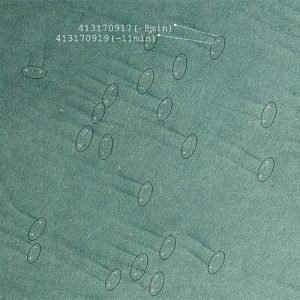
Detail of a satellite image that shows a pair of Chinese trawlers in North Korean waters. © Planet
But we wanted to be sure. So the Global Fishing Watch technical team, working with colleagues in Japan and South Korea, acquired more satellite data, including widespread optical imagery from the company Planet and radar imagery from a few different sources. By working with these satellite companies and government agencies, we were able to identify, in detail, the fishing activity across multiple years and even estimate the catch of these vessels. Our blog by Jaeyoon captures well how we worked together to produce the study Illuminating dark fishing fleets in North Korea, published in Science Advances.
Ensuring the paper is widely seen and read is also vital, that’s why we worked with investigative reporter Ian Urbina of The Outlaw Ocean Project and NBC News on their in-depth report. This report revealed the key findings of our research and highlighted the high humanitarian cost of this unregulated fishing.
The Global Fishing Watch research team used an unprecedented synthesis of satellite imagery and machine learning to uncover the dark fleets. It seems that this sort of work would not have been possible even a few years ago. Can you describe how the fields of satellite imagery and machine learning have evolved as tools for tracking industrial fishing vessels?
Since 2014, the number of satellites observing the earth has increased several fold, and hundreds are now in orbit. At the same time, machine learning techniques, such as the ability to detect objects in images, have matured and the availability of big data processing has also increased. The result is that it is now possible to process terabytes or petabytes of imagery to monitor human and natural activity across the globe. We can now monitor deforestation in real time and count the extent of specific crops in agriculture. And we can measure fishing activity.
For this research project, we drew on imagery from both private and public sources. Planet, a company that provides geospatial insights from more than 350 satellites orbiting Earth, supplied the most imagery. Using its satellites, Planet was able to share daily imagery of North Korean waters. We were able to apply image recognition techniques to identify pair trawlers operating in the waters. We then drew on NASA satellite imagery and radar imagery from a few different commercial and government sources, and combined this information with GPS positions that were broadcast by some of the vessels.
We know that good fisheries management depends on good data and enforcement. What does this story tell us about the future of multinational cooperation and data sharing for transboundary fisheries management? Is there reason to think that we are in a new era of tracking and monitoring illegal fishing activity?
In the waters between the Koreas, Japan, and Russia, countries have generally shared very little information. As a result, there has been no way to understand: 1) why squid populations have been declining, and 2) what to do about it. In the past, when confronted, China denied that there was a sizable fleet fishing in North Korean waters.
Now, with this satellite technology, we can clearly show all parties the fishing activity happening in these waters. The fishing techniques being used reveal the scale and intensity of fishing activity by vessels originating from China. We were also able to observe fishing efforts undertaken by the South Korean and Japanese fleets. (The Russian fleet generally does not target squid.) As a result, negotiations about how to manage the fishery can now be informed by real data instead of speculation. While it will take some time to see if this new information changes the management, we know that revealing the fishing activity is a necessary step.
With these new technologies, it will be impossible for industrial fishing vessels to operate without being observed by satellites in some way. As a result, we believe that there will be less incentive to try to hide activity and hopefully actors will be forced to—or strongly encouraged—to explain and share their activity.
Finally, at Global Fishing Watch, we’ve seen many good examples of how clear data can inform negotiations over fisheries management. For instance, our research partners at National Geographic Pristine Seas, led by Enric Sala, have, over the past few years, negotiated the creation of seven large marine protected areas (MPAs) across the globe with a combined area larger than Egypt. To help create these MPAs, Pristine Seas engaged in negotiations with different governments, and in each case used Global Fishing Watch fishing effort data to show how the fishing industry would (or would not) be affected by proposed closures. In some cases, the fishing industry argued that the closure would destroy their business but the data was able to show that the MPAs would actually only affect their business in a relatively small way.
With these new technologies, it will be impossible for industrial fishing vessels to operate without being observed by satellites in some way. As a result, we believe that there will be less incentive to try to hide activity and hopefully actors will be forced to, or strongly encouraged to, explain and share their activity.
Aside from broader issues of fisheries governance, this case has significant implications for North Korean small-scale fishers who have been competing against more durable and well-equipped foreign vessels. Can you describe the human element of this story and what your team learned about the impact of illegal fishing on North Korean fishers themselves?
In addition to discovering hundreds of large, industrial fishing vessels, originating from China and operating in North Korean waters, we found that several thousand small, wooden North Korean vessels were operating, mostly illegally, in Russian waters, hundreds of miles from their home port. We suspect the reason that these vessels are fishing in Russian waters instead of the closer, North Korean water is that they likely cannot share seaspace with the larger pair trawlers coming from China.
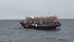
A North Korean small scale fishing boat (<20m long) in operation in the Russian EEZ (recorded between August and October 2018). © Seung-Ho Lee
These North Korean boats are ill equipped to be so far at sea. Their engines are small and they appear to lack refrigeration—the pictures we have seen show ghost boats—sometimes with the crew alive, and sometimes not. Based on our count of the number of vessels at sea and the reported number of vessels that wash ashore, we estimate that somewhere between one-tenth and one-thirtieth of the vessels are shipwrecked in a given year. It is said that there are villages in North Korea called “widow villages” because of the family members lost at sea.
What’s next for the Global Fishing Watch team? Will you seek to apply these technologies in other regions of the world where illegal fishing by dark fleets is suspected? Is there potential for scale in transferring these techniques?
We plan to take these technologies global and monitor the activity of all large industrial vessels at sea. There are already free feeds of optical and radar imagery available, and we are building partnerships with satellite providers who can augment these with commercial imagery. When combined with GPS data we have already collected, we will be able to identify all the large vessel traffic in the world, including all the fishing vessels that are not broadcasting their activities. The result will be that large, industrial fishing vessels intent on operating outside the law will not be able to hide their activity. What happens in the global commons, the open ocean, will become common knowledge.
When combined with GPS data we have already collected, we will be able to identify all the large vessel traffic in the world, including all the fishing vessels that are not broadcasting their activities. This will shine a bright light on what happens in the open ocean for all the world to see.
Read the ground-breaking study Illuminating dark fishing fleets in North Korea published in the journal Science Advances here.
Learn more about the background of this study in a video by Global Fishing Watch. © Global Fishing Watch